The Winter They Spent Here
How a Corps of Discovery became neighbors on the upper Missouri
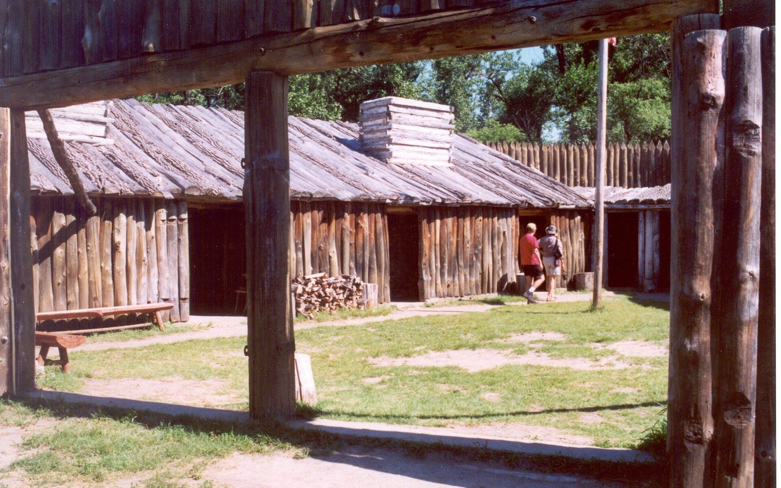
On the east bank of the Missouri, downstream from the mouth of the Knife River and just downstream from the earthlodge villages that had stood there for generations, a small American military expedition spent the winter of 1804–05 in a triangular log fort of their own construction. They were cold, often hungry, and completely dependent on the goodwill and knowledge of the Mandan and Hidatsa people around them. By the time they broke the river ice and headed upriver in the spring, they had spent more time camped on the upper Missouri than at any other point on their entire journey. That winter shaped the expedition more than most accounts acknowledge — and McLean County is where it happened.1
The villages they found
The Mandan and Hidatsa had been living in permanent earthlodge villages along this reach of the Missouri for centuries. By the time Meriwether Lewis and William Clark arrived in the fall of 1804, the Knife River confluence was the most densely populated region on the upper Missouri — a major center of trade that drew Plains tribes from hundreds of miles in every direction. The villages were not frontier outposts.2 They were established communities with sophisticated agriculture, trade networks reaching from the Gulf Coast to the northern Great Plains, and deep knowledge of the river, the landscape, and the peoples to the west.
Five principal villages stood within a few miles of each other: two Mandan villages and three Hidatsa. The Corps of Discovery built their winter quarters, which they named Fort Mandan, roughly a mile downstream from the nearest Mandan village. The proximity was deliberate and practical. The expedition needed food, information, and diplomatic access, and they could not have wintered here without what the villages provided. Corn, dried squash, and meat came from the villagers. Geographic intelligence about the country ahead — including the critical question of what route to follow across the Continental Divide — came from Hidatsa men who had traveled far to the west. The idea of engaging Toussaint Charbonneau as an interpreter, and through him his wife Sakakawea, arose directly from those conversations.
What Fort Mandan actually was
The fort Lewis and Clark built was a working structure, not a permanent post. Two rows of huts formed the sides of a triangle, with a high stockade wall facing the river. The men lived crowded together through a winter that reached temperatures far below zero. They hunted, repaired equipment, made moccasins, and documented everything — plants, animals, soils, political structures, trade goods — with the systematic thoroughness that President Jefferson had demanded. Captains' journals, enlisted men's diaries, and botanical and zoological specimens were prepared here to be sent back downriver in the spring. The keelboat that turned downriver in April 1805 carried the most substantial body of natural history data yet collected from the interior of North America.
The fort itself did not survive long after the expedition departed. The original site eroded into the Missouri over time, as the river worked its slow way into the bank. The location of the original Fort Mandan is marked and recognized, but what visitors see today is a full-scale reconstruction built nearby. It sits a few miles southwest of Washburn, and it serves its purpose well: standing inside the log walls in a Dakota winter, you understand immediately what the expedition's journals mean when they describe the cold.
The Lewis and Clark Interpretive Center
The interpretive center at Washburn, maintained by the State Historical Society of North Dakota, is the most thorough resource for this chapter of history within the county. It is not a replica or a souvenir experience — it is a serious regional museum that treats both the expedition and the upper Missouri villages with the kind of depth the subject deserves.
The exhibits trace the full arc of the winter encampment: the diplomatic encounters, the trading relationships, the collection of geographic and scientific knowledge. They give space to the Mandan and Hidatsa perspective, which the captains' journals render only partially and from the outside. The upper Missouri villages had been managing complex diplomatic relationships with many different nations for generations before 1804. Lewis and Clark were, in one sense, simply the latest travelers to arrive needing something. The center makes that context plain without reducing it to a talking point.
There is real interpretive work here on Sakakawea herself — her background as a Shoshone woman taken captive and brought north, her role as the expedition moved west, and the fact that her knowledge of the land and people beyond the Rockies was more operationally significant to the Corps than her husband's services as an interpreter. The county carries her name on its largest geographic feature, Lake Sakakawea, which says something about how central she became to the region's sense of its own history. The interpretive center is where that history gets the careful treatment it deserves.
Why it matters that they stayed
American history tends to frame the Lewis and Clark expedition as a journey — movement as the point, the Pacific as the destination. The winter on the upper Missouri cuts against that framing usefully. For roughly five months, the expedition was stationary, embedded in an existing community, surviving on knowledge and food that community provided.
What the Corps learned here was not incidental. The geographic information gathered from Hidatsa informants during the winter fundamentally shaped the route Lewis and Clark followed the following summer — including the decision about which fork of the Missouri to take, and the plan to cross the mountains at the point where the Shoshone might be found with horses to trade. The botanical and zoological collections sent downriver from this spot were extensive enough to significantly advance American natural history. The diplomatic encounters with the Mandan and Hidatsa were among the most substantive the expedition conducted anywhere along the route.
And all of it happened within a few miles of where the Knife River villages had stood for generations — a fact that does not diminish the expedition's significance but does locate it correctly in a longer history.
Coming here now
The reconstruction of Fort Mandan and the Lewis and Clark Interpretive Center sit a short drive from Washburn, close enough to combine in a half-day or fill an easy full day if you linger. The site on the river is open ground, and in the right season the light on the Missouri does what it always does — it changes constantly, and it is easy to stand there and understand why people chose this stretch of water.
The Knife River Indian Villages National Historic Site, administered by the National Park Service, lies a bit further west near Stanton, and a visit there pairs naturally with the interpretive center. The earthlodge depressions still show in the grass. Interpretive trails connect the village sites. Together, the two sites give you the full picture: the permanent communities that anchored this place for centuries, and the winter guests who arrived in October and left the following April carrying a transformed understanding of the continent.
Driving into this part of central North Dakota from the south or east, it is easy to read the landscape as empty — flat, wide, undifferentiated. It is not, and never was. The Missouri cut through here, the villages stood here, the expedition wintered here. The country holds all of it. You only have to know where to look.3
How it happened
- Centuries before 1804Mandan and Hidatsa establish permanent earthlodge villages near Knife River
- Fall 1804Corps of Discovery arrives, builds Fort Mandan
- Winter 1804–05expedition winters at Fort Mandan, gathers geographic intelligence
- April 1805expedition departs upriver; keelboat with specimens and records sent back downriver
End-notes
Asides from the editors — the things that did not belong in the piece itself.
Five months in one place, out of a journey almost always told as constant motion. The stillness is the part that gets left out, and it is the part that happened here. ↩ back
Worth repeating in a visitor guide, because the mythology is durable: the expedition arrived as guests in a populated, farming, trading landscape that had been managing its own diplomacy for generations. ↩ back
Which is the whole argument for starting at the Interpretive Center rather than the river. Go and get the context first; the water will still be there afterwards. ↩ back