What the Garrison Dam Actually Did
The dam was built to solve three problems at once — and it did, at a price the river villages paid
The Garrison Dam is the fifth-largest earthen dam in the United States by volume. It sits across the Missouri River in Riverdale, holding back what became Lake Sakakawea — a reservoir stretching more than 170 miles upstream into the high plains. The dam did exactly what it was designed to do. Whether that was worth it depends on what you had to lose.
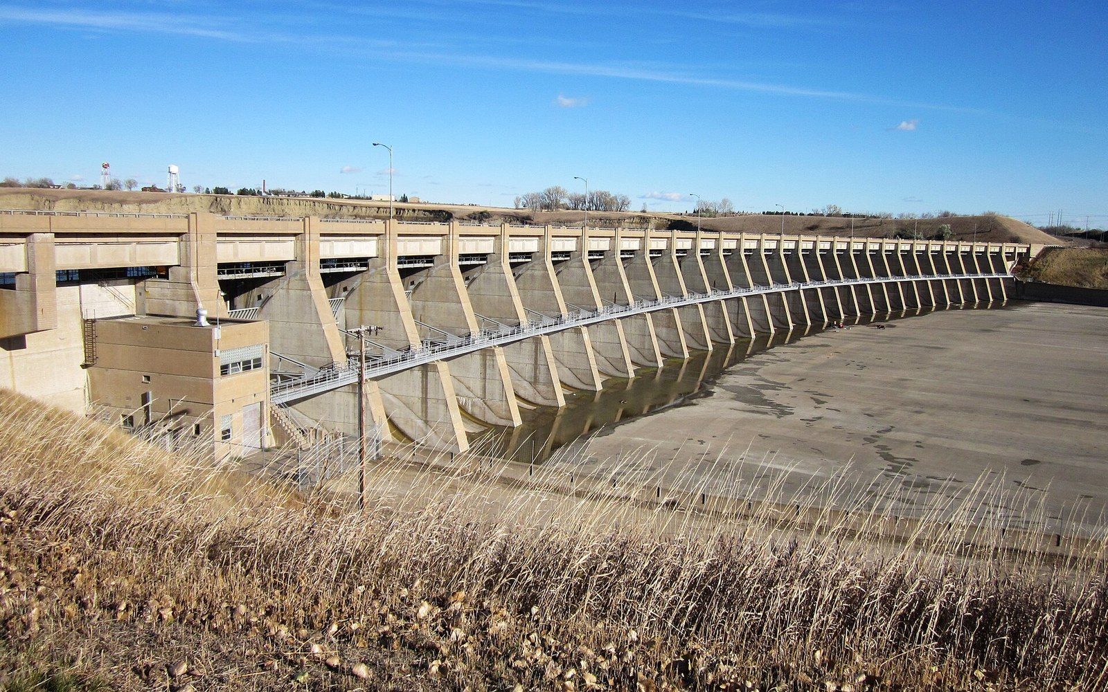
Construction began in the late 1940s and finished in the mid-1950s, a project of the U.S. Army Corps of Engineers under the broader Pick-Sloan Missouri Basin Program — a plan hammered out after catastrophic flooding on the Missouri and its tributaries had made it clear the river could not be left alone. The dam that rose at Riverdale was a massive earthen structure: not poured concrete but compacted earth and rock, built wide and low against the bluffs, with a powerhouse tucked at its base where the river exits.
Three things drove it. Flood control downstream. Hydroelectric power for the region. And navigation — keeping the Missouri deep enough for barge traffic south toward Sioux City and beyond. The dam accomplished all three. What it also did was flood approximately 155,000 acres of North Dakota land, most of it belonging to the Three Affiliated Tribes — the Mandan, Hidatsa, and Arikara — of the Fort Berthold Reservation. That loss sits at the center of any honest account of what this dam actually did.2
Flood control: the problem was real
Before the dam, the Missouri below its confluence with the Yellowstone was a notoriously unpredictable river. In wet years it moved enormous volumes of water southward in pulses that overwhelmed downstream banks, towns, and farms — not just in North Dakota but in South Dakota, Nebraska, Iowa, Missouri. The flood of 1943 alone caused severe damage across the basin.1 The Pick-Sloan plan, passed by Congress in 1944, was conceived in direct response to that pattern, and the Garrison Dam was the northernmost and largest piece of it.
The dam works by capturing that water. When runoff from the northern plains swells the upper Missouri and its tributaries — the Little Missouri, the Yellowstone, the White Earth — the reservoir absorbs the surge. The Corps releases water in controlled volumes through the dam's outlets, maintaining a steadier, manageable flow downstream. In practice this has dramatically reduced catastrophic flooding in the lower basin. Communities downstream that once braced for spring flood watches now face a different, more regulated river.
What that regulation also removed was the Missouri's natural flood pulse — the annual rise and fall that had sustained cottonwood stands, sandbar habitat, and the migratory bird species that depended on them. The river below the dam is colder, clearer, and more even-tempered than the pre-dam Missouri, and not all of those changes are improvements for the ecology. The Missouri below Garrison is in many ways a different river than the one Lewis and Clark came up.
Power: what the dam produces
The Garrison Dam powerhouse is a working facility, not a monument. Its generators produce hydroelectric power fed into a regional grid, making the dam an ongoing economic asset decades after construction costs were absorbed. The power output varies with reservoir elevation and regional demand, but the plant has operated continuously since the 1950s and remains a significant source of electricity for the upper Great Plains.
Riverdale — the town built specifically to house dam construction workers — still exists largely because of the powerhouse and the ongoing presence of the Corps of Engineers. It is one of the more unusual communities in the county: a planned federal town that never fully transitioned to a private economy, and whose layout still reflects its origins in federal design. The dam is the reason Riverdale exists at all, and the reason it looks the way it does.
For the county more broadly, the dam and the reservoir it created reshaped the local economy in ways that are still working themselves out. Commercial fishing, recreation, and the walleye fishery centered on Garrison all trace their origin to the reservoir. The lake brought money from outside the county — anglers, boaters, campers — in volumes the pre-dam, pre-reservoir Missouri never did. Fort Stevenson State Park sits on the north shore that would have been river bottom before the reservoir filled. The Audubon National Wildlife Refuge and Lake Audubon sit in a landscape defined by the reservoir's presence. Nearly everything recreational in the county north of Washburn exists in relationship to the dam.
The land that went under
The cost of all this was borne disproportionately by the Three Affiliated Tribes. The reservoir's footprint took roughly a quarter of the Fort Berthold Reservation — not marginal land but the most productive land the tribes held. The Missouri River bottomlands that went under were the agricultural core of the reservation: the garden ground, the timber, the sheltered valley where most of the reservation's population actually lived. Villages were inundated. Families were relocated — many to higher, more exposed ground on the surrounding uplands, away from the bottomland they had farmed and the river they had lived beside for generations.
The Mandan, Hidatsa, and Arikara had been peoples of the upper Missouri for centuries. Their earthlodge villages had been among the most significant population centers on the northern plains before epidemic disease in the 1800s reduced their numbers catastrophically. What remained of the reservation's Missouri bottomlands carried that history — including sites, burial grounds, and landscapes with deep cultural meaning. The reservoir covered most of it.
Federal compensation negotiated at the time was widely understood, including by congressional advocates for the tribes, to be inadequate. Additional compensation was passed by Congress decades later, though it could not restore the land or the communities that had been displaced. The loss remains a live issue for the Mandan, Hidatsa, and Arikara Nation — not a historical footnote but a formative injury in living memory for many tribal members and their descendants.
Any account of the Garrison Dam that focuses only on flood control and hydroelectric output is an incomplete account. The dam solved a problem for people downstream at a cost paid almost entirely by people upstream, and the distribution of that cost was not accidental. The Pick-Sloan plan authorized the use of reservation land with less procedural protection than it afforded non-tribal land, a disparity documented in congressional records and subsequent scholarship on the Pick-Sloan era.
What it looks like now
Standing on the dam's crest at Riverdale, you look north into the reservoir — a body of water that extends so far you lose the far shore in haze or distance. To the south, the river exits the powerhouse and runs cold and fast past the boat ramp at the base of the dam, a stretch of water that draws anglers specifically for its below-dam fishery, where cold, oxygen-rich releases produce conditions different from the open reservoir. The contrast between the two sides is immediate and physical: one side is lake, one side is river, and the dam is the reason.
The structure itself is worth a slow look.3 Earthen dams have a different presence than concrete ones — longer, more gradual, less obviously architectural. The Garrison Dam is wide enough that the road across its crest feels like a highway through a low ridge rather than a crossing of an engineering structure. The Missouri River bluffs that frame the valley on both sides are the same bluffs that would have framed the river before; the water between them is not.
Lewis and Clark came up this stretch of river in the fall of 1804, heading toward their winter camp at Fort Mandan, noting the river's character and the bluffs above it. The river they traveled was unregulated, variable, and alive with sediment. The reservoir behind the dam today is a different body of water in almost every physical respect, though it occupies the same valley. That continuity and discontinuity — the same place, remade — is what the Garrison Dam actually did.
How it happened
- 1943severe Missouri River flooding accelerates political pressure for a dam
- 1944Pick-Sloan Missouri Basin Program passed by Congress
- late 1940sGarrison Dam construction begins
- mid-1950sdam completed, reservoir begins filling
End-notes
Asides from the editors — the things that did not belong in the piece itself.
Worth saying plainly, because the argument gets flattened in both directions: nobody invented the flooding to justify the dam. The river genuinely did this, repeatedly, to people downstream. ↩ back
We keep the engineering and the dispossession in one piece deliberately. Splitting them into two articles would let a reader pick the comfortable half and skip the other, which is exactly how this history usually gets told. ↩ back
Give it ten minutes from the crest and ten from the base. They do not read as the same structure, and only the second one makes the scale physical. ↩ back